4/12 Finally no more hard WNW wind. Anchor up at 10AM a little late. Leaving San Juanico. Plan is to sail as far north as we can get to Coyote. ESE winds. 2 ft swell. Most of the day. Best beam reach of our trip. Holding 6.5 kts sometimes 7! Pulled into view of tiny San Sebastian aka Puerco. Adorable little bay but with East wind and swell growing it looked uncomfortable and ‘Splendid Isolation’ was loving this beam reach. Claire threw our first reef into the main and we cruised on. 20 miles left to Santo Domingo. 15:00 Cruising 5.5 kts with just enough time to make it by dusk! Anchor down at 20:30 off Sombrerito just outside the Mulegé river mouth. Decided to go here over Domingo or Coyote. Uncomfortable rocking with the sets but we made it through the night. We almost ran aground coming in the dark. Greatest day of sailing yet. Wing and wing off Punta Conception. Over 5 kts all day, usually 6+. Someone hailed uf on the VHF but we missed it because I was setting the anchor and claire was pulling the dinghy in. Oh well.
4/13 “HARD TO PORT!” repeated in my head all night. That’s what I had shouted to Claire when I saw the shoal and shoreline, hearing voices from the restaurant. We came close last night. Horrible depth perception in the dark, plus over the shoal was more water, so it all blended together. Woke up every few hours to check the depth sounder. Depths of 17 feet and 13 feet at low tide just before sunrise. It got calm for a few hours in the still of the night. Back to slight north breeze and rocking with the stunning sunrise. Fluffy clouds out there make me think of south winds. Now that I can see...we almost beached it last night. We’re anchored literally on the shore. WOW. We are officially grounding sluts. 4th time? 5th? Anchor up around 7:30. We motored out off the river mouth. Scoped it out and watched pangas go up the channel. Our cruising guides say its possible for shallow draft boats to get into the rivermouth, to anchor or tie to the small pier. Which sounded nice, calm, and a quick dinghy ride up the river to town. So we crept in at 1.5 knots sounding 11ft. All good. Got in and saw that since our out of date cruising guides, things have changed. Not at all as spacious as it seemed on paper. As we decided to abort, we grounded. I checked the sounder. Said 10 ½ feet. Put a stick over the side and stuck the bottom. I reset the depth sounder so its as accurate as can be. It’s been offset by 5 feet this whole time. So last night was actually only 7 feet of water right off the shore. We tried to push off with the stick and reverse the motor. That had worked in La Paz. Not here, it was sediment river mouth, soft bottom. Luckily I timed it with the tide and it was getting higher for the next hour. I dinghyed off the old dock and it was a few feet deeper, but not worth sticking around for. After some patience we floated up off the bottom while Claire spun the boat around 180º. Got out of there around 9AM. En route to Coyote Bay. North wind picked up. South was forecasted. Which was ok because we flew down the entry way. Very thankful we sailed over 50 miles yesterday. Anchor down in Coyote Bay, east of Isla Ramon. Gorgeous houses. Good wind protection. 17’ of water.
not our photo. but this is why we sailed here!
i'm sure most of our posts are confusing. hope this helps. the lowest waypoint is San Juanico. the middle point is san sebastian aka puerco, where we planned to stop but the swell wasn't the right direction so we continued to the top waypoint which is Mulegé.
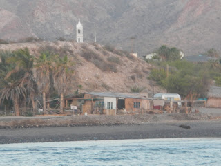
This is what we woke up to! super shallow and super close to shore.
looks like a little sombrero right?
that restaurant looked way more inviting in the dark.
sorry no photos of us getting stuck in the river mouth. they would have been entertaining but due to the fact of the matter we were busy and couldn't take photos. usually why we don't have many open water photos as well.
Link: http://en.wikipedia.org/wiki/Punta_el_Sombrerito


No comments:
Post a Comment